Paweł Netzel - {Math can do that}
"The essence of math is not to make simple things complicated,
but to make complicated things simple."
"The essence of math is not to make simple things complicated,
but to make complicated things simple."
I am a mathematician, climatologist, GIS analyst and software developer. Since 2009 I am a member of OSGeo Chapter Poland. Since 2015 I am a member of IEEE. Since 2016 I am a member of IEEE Geoscience and Remote Sensing Society and International Association for Mathematical Geosciences
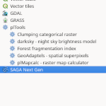
The plTools package includes binaries for plMapcalc, plForestFragment, plGeoAdaptels
plDarkSky, plClump4p, and QGIS plugin.
GIT repo
This is an extension to the two-scan CCL78 algorithm aimed at reduction of
the time necessary to label all clumps in a giga-cell raster by two-to-three orders
of magnitude
GIT repo
plGeoAdaptels obtains raster superpixels that are smaller or
larger in areas of high or low spatial complexity, respectively,
thereby achieving scale-adaptiveness.
GIT repo

ezGDAL library is a layer between GDAL library and user program. It allows to
acces GDAL data (GeoTIFF) in two modes: as scan lines or horizontal buffer
divided into squares (frames).
GIT repo
Source code and binaries for the software above are available in Git repository
2024
♦ L.Tyminska-Czabanska, P.Janiec, P.Hawryło, J.Ślopek, A.Zielonka, P.Netzel, D.Janczyk, J.Socha 2024: Modeling the effect of stand and site characteristics on the probability of mistletoe infestation in Scots pine stands using remote sensing data. Forest Ecosystems, DOI: 10.1016/j.fecs.2024.100191, preprint
♦ P.Netzel, L.Tyminska, D.D.Feleha, J.Socha 2024: New approach to assess forest fragmentation based on multiscale similarity index. Ecological Indicators, vol. 158, DOI: 10.1016/j.ecolind.2023.111530, preprint
2023
♦ J.Socha, P.Hawryło, L.Tymińska-Czabańska, B.Reineking, M.Lindner, P.Netzel, E.Grabska-Szwagrzyk, R.Vallejos, C.P.O.Reyer 2023: Higher site productivity and stand age enhance forest susceptibility to drought-induced mortality. Agricultural and Forest Meteorology, Vol. 341, DOI: 10.1016/j.agrformet.2023.109680
2022
♦ P.Netzel, T.F. Stepinski 2022: Segmentation of global climate dataset into contiguous spatial units having quantitatively homogeneous climates. International Journal of Climatology, Vol. 42, Issue 13, pp. 6741-6752, DOI: 10.1002/joc.7606, preprint
2021
♦ L.Tymińska-Czabańska, J.Socha, P.Hawryło, R.Bałazy, M.Ciesielski, E.Grabska-Szwagrzyk, P.Netzel 2021: Weather-sensitive height growth modelling of Norway spruce using repeated airborne laser scanning data. Agricultural and Forest Meteorology, Vol. 308–309, 108568, ISSN 0168-1923,DOI: 10.1016/j.agrformet.2021.108568, link
♦ P.Netzel, J.Ślopek 2021: Comparison of different implementations of a raster map calculator. Computers & Geosciences 2021, DOI: 10.1016/j.cageo.2021.104824, link, preprint
2020
♦ J. Socha, P.Netzel, D.Cywicka 2019: Stem taper approximation by artificial neural network and a regression set models. Forests 2020, 11(1), 79; DOI: 10.3390/f11010079, link, preprint
2019
♦ J. Nowosad, T.F.Stepinski, P.Netzel, 2019: Global assessment and mapping of changes in mesoscale landscapes: 1992–2015. International Journal of Applied Earth Observation and Geoinformation, vol.78, pp. 332-340, DOI: 10.1016/j.jag.2018.09.013, link, preprint
2018
♦ H. Netzel, P. Netzel, 2018: High resolution map of light pollution. J. of Quantitative Spectroscopy and Radiative Transfer, Vol. 221, pp 300-308. DOI: 10.1016/j.jqsrt.2018.05.038, link, preprint
♦ P.Netzel, T.F.Stepinski, 2018: Climate Similarity Search - GeoWeb Tool for Exploring Climate Variability. Bull. Amer. Meteor. Soc., March 2018, pp. 475-477. DOI: 10.1175/BAMS-D-16-0334.1, link
2017
♦ A.Dmowska, T.F.Stepinski, P. Netzel, 2017: Comprehensive framework for visualizing and analyzing spatio-temporal dynamics of racial diversity in the entire United States. PLoS ONE 12 (3): e0174993. DOI: 10.1371/journal.pone.0174993, link
♦ P. Netzel, T.F.Stepinski, 2017: World Climate Search and Classification Using a Dynamic Time Warping Similarity Function. Advances in Geocomputation, pp. 181-195. DOI: 10.1007/978-3-319-22786-3_17, link, preprint
2016
♦ H. Netzel, P. Netzel, 2016: High resolution map of light pollution over Poland. J. of Quantitative Spectroscopy and Radiative Transfer, Vol. 181, pp. 67-73. DOI: 10.1016/j.jqsrt.2016.03.014, link, preprint, results web page
♦ P. Netzel, T.F. Stepinski, 2016: On using a clustering approach for global climate classification. Journal of Climate. Vol. 29, no 9, pp.3387–3401. DOI: 10.1175/JCLI-D-15-0640.1, preprint, paper
2015
♦ M. Kryza, A. Drzeniecka-Osiadacz, M. Werner, P. Netzel, A.J. Dore, 2015, Comparison of the WRF and Sodar derived planetary boundary layer height, Int. J. Environment and Pollution, Vol. 58, Nos. 1/2, pp.3-1. DOI: 10.1504/IJEP.2015.076579
♦ J.Jasiewicz, P. Netzel, T.F. Stepinski, 2015, GeoPAT: A toolbox for pattern-based information retrieval from large geospatial databases, Computers & Geosciences, vol.80, pp.62-73, DOI: 10.1016/j.cageo.2015.04.002, preprint, paper
2014
♦ P. Netzel, T.F. Stepinski, 2014, Pattern-based assessment of land cover change on continental scale with application to NLCD 2001-2006, IEEE Transactions on Geoscience and Remote Sensing, Vol:53 Issue:4, pp.1773-1781, DOI: 10.1109/TGRS.2014.2348715, paper, preprint
♦ J. Jasiewicz, P. Netzel, T.F. Stepinski, 2014, Landscape similarity, retrieval, and machine mapping of physiographic units, Geomorphology 221, pp.104-112 DOI: 10.1016/j.geomorph.2014.06.011, paper, preprint
♦ T.F. Stepinski, P. Netzel, J. Jasiewicz, 2014, LandEx - A GeoWeb tool for query and retrieval of spatial patterns in land cover datasets. IEEE Journal of Selected Topics in Applied Earth Observations and Remote Sensing 7(1), pp.257-266 DOI: 10.1109/JSTARS.2013.2260727, paper, preprint
♦ M. Kryza, P. Netzel, A. Drzeniecka-Osiadacz, M. Werner, A. J. Dore, 2014, Forecasting the Ozone Concentrations with WRF and Artificial Neural Network Based System, Air Pollution Modeling and its Application XXII, p. 605-609 10.1007/978-94-007-5577-2_102, paper, preprint
2013
♦ P. Netzel and T.F. Stepinski, 2013, Connected Components Labeling for Giga-Cell Multi-Categorical Rasters. Computers and Geosciences 59, pp 24-30 DOI: 10.1016/j.cageo.2013.05.014, paper, preprint
2012
♦ M. Kryza, M. Werner, A. J. Dore, M. Blas, A. Drzeniecka-Osiadacz, P. Netzel, 2012, Modelling meteorological conditions for the episode (December 2009) of measured high PM10 air concentrations in SW Poland - application of the WRF model, Int. J. of Environment and Pollution, vol. 50, p. 41-52 DOI: 10.1504/IJEP.2012.051179, paper
♦ A. Drzeniecka-Osiadacz, P. Netzel, J. Slopek, 2012, Verification of SBL models by mobile SODAR measurements, Int. J. Environment and Pollution, vol. 50, Nos. 1/2/3/4, p. 250-263 DOI: 10.1504/IJEP.2012.051197, paper, preprint
♦ M. Pietras, P. Netzel, 2012, The method of assessment of solar potential for selected area with use Geographical Information Systems, European Physical Journal (EPJ) Web of Conferences, vol. 33. DOI: 10.1051/epjconf/20123301010, paper, preprint
2011
♦ Kazimierz Kurzawski, Andrzej Kijowski, Krzysztof Kucharczyk, Pawel Netzel, 2011, Computer systems for supporting the process of training in shooting sports, part 2, Sport Wyczynowy, 4 (awarded as the best paper of 2011)
♦ Kazimierz Kurzawski, Andrzej Kijowski, Krzysztof Kucharczyk, Pawel Netzel, 2011, Computer systems for supporting the process of training in shooting sports, part 1, Sport Wyczynowy, 3 (awarded as the best paper of 2011)
♦ Malgorzata Pietras, Pawel Netzel, 2011 Evaluation of solar potential of the selected area using GIS tools, the example of using GRASS system, in: J. Kasperski (ed.), 2011, Proceedings of Lower Silesia Energy Efficient Home, Publishing House of Technical University of Wroclaw, p. 151-158
♦ Pawel Netzel, 2011, Implementation of artificial neural networks in the system GRASS, in: Pawel Netzel (ed.), 2011, Spatial analysis with GRASS, Scientific Dissertations of the Institute of Geography and Regional Development 15, University of Wroclaw, Wroclaw, p. 75-88 paper
♦ Pawel Netzel, Jacek Slopek, 2011, Calculation of the terrain roughness in the urban area using GRASS, in: Pawel Netzel (ed.), 2011, Spatial analysis with GRASS, Scientific Dissertations of the Institute of Geography and Regional Development 15, University of Wroclaw, Wroclaw, p. 35-42 paper
♦ Pawel Netzel, Anetta Drzeniecka-Osiadacz, Jacek Slopek, 2011, Mobile SODAR measurements as a source of information about spatial variability of nocturnal thermal inversion height, Joint Urban Remote Sensing Event, pp. 141-144, doi: 10.1109/JURSE.2011.5764739 paper
♦ Emilia Wozniak, Adam Iwaniak, Pawel Netzel, 2011, Utilisation of OGC standards for data visualisation in the spatial data infrastructure, Part 2, Przeglad Geodezyjny, R.83, no.5, p. 12-17 abstract
♦ Emilia Wozniak, Adam Iwaniak, Pawel Netzel, 2011, Utilisation of OGC standards for data visualisation in the spatial data infrastructure, Part 1, Przeglad Geodezyjny, R.83, no.4, p. 3-8 abstract
2010
♦ Adam Iwaniak, Tomasz Kubik, Pawel Netzel, Witold Paluszynski, 2010, Overcoming obstacles to the implementatation of the INSPIRE directive, Annals of Geomatics, Vol VIII, No. 1 (37), Warsaw, p. 63-72 paper
♦ Anetta Drzeniecka-Osiadacz, Pawel Netzel, 2010, Influence of meteorological conditions and atmospheric circulation on PM10 mass concentration in Wroclaw, Proceedings of ECOpole, Vol 4, no. 2, p. 343-349 paper
2008
♦ Adam Iwaniak, Bartosz Kopanczyk, Tomasz Kubik, Pawel Netzel, Witold Paluszynski, 2008, Implementing catalogue services using free and open source software, Annals of Geomatics, Vol. VI, no.7, p.15-21 paper
♦ Adam Iwaniak, Bartosz Kopanczyk, Tomasz Kubik, Pawel Netzel, Witold Paluszynski, 2008, Examples of construction of spatial data infrastructures on the Powiat (county) level with use of free software, Annals of Geomatics, Vol VI, no. 7, p. 7-14 paper
2004
♦ Andrzej Kijowski, Pawel Netzel, 2004, Methods of computer visualization in sports shooting training, in shooting sports - modern training solutions - a collective work edited by Kazimierz Kurzawskiego, Publisher BK, PZSS, Warsaw
2002
♦ Anetta Drzeniecka, Maria Dubicka, Pawel Netzel, Jerzy L. Pyka, Dariusz Rosinski, Sebastian Sikora, Mariusz Szymanowski, 2002, System of the meteorological measurements in the climate researches, Man and climate in the 20th century, Wroclaw
♦ Marek Blas, Mieczyslaw Sobik, Friedrich Quiel, Pawel Netzel, 2002, Temporal and spatial variations of fog in the Western Sudety Mts., Poland, Atmospheric Research, Vol. 64 (2002), Issues 1-4, p. 19-28, Elsevier paper preprint
♦ Pawel Netzel, Jacek Slopek, 2002, A GIS computer laboratory based on free software, internet publication
2001
♦ Mieczyslaw Sobik, Pawel Netzel, Friedrich Quiel, 2001, Application of the raster model to determine the field of annual total precipitation in Lower Silesia, [in:] Wyszkowski A. (ed.), The use of gridded data in climatology and hydrology, Yearbook of Physical Geography, University of Gdansk, 4, p. 27-34
♦ Pawel Netzel, Lidia Netzel, 2001, GRASS software in research and education of the Department of Meteorology and Climatology, University of Wroclaw, GIS and remote sensing in the structure and functioning of the landscape, Nicholas Copernicus University
1998
♦ Maria Dubicka, Pawel Netzel, 1998, Computer meteorological measurement system at the meteorological observatory in Wroclaw, Acta Univ. Wratisl., 2022, Pr. Inst. Geogr., Series C, Meteorology and Climatology, V, p. 101-106
1997
♦ Andrzej Kijowski, Pawel Netzel, 1997, Computerized method of recording and analysis of the sports shooting course, an example R.Mauer starting in 1996 Atlanta Olympics, International Scientific-Methodical Conference: "The effectiveness of training programs in sport", Spala 1996, published by the Office of Culture Physical Education and Tourism, Quarterly Training Methodology, 3, II, p. 113-122
1996
♦ Pawel Netzel, 1996, The possibility of using a computer system to read analog registrograms on the example of temperature registration, Acta Univ. Wratisl., 1794, Pr. Inst. Geogr., Series C, Meteorology and Climatology, III, p. 83-86
1995
♦ Pawel Netzel, Slawomir Stano, Maciej Zarebski, 1995, Monostatic Verical Doppler SODAR VDS, News IMGW, XVIII (XXXIX), 3-4, p. 119-125, Krakow
1994
♦ Pawel Netzel, Jacek Piasecki, 1994, The system for the collection and initial processing of SODAR computer continuous recordings at the meteorological station in the Klesnica Valley (Sneznik massif), Acta Univ. Wratisl., 1590,Pr. Inst. Geogr., Series C, Meteorology and Climatology, I, p. 121-130
- PostDoc at Space Informatics Lab, University of Cincinnati, OH, USA, 23.03.2015-30.06.2017
- Short-term Scholar at Space Informatics Lab, University of Cincinnati, OH, USA, 14.06.2014-21.07.2014
- Short-term Scholar at Space Informatics Lab, University of Cincinnati, OH, USA, 05.02.2014-23.02.2014
- Short-term Scholar at Space Informatics Lab, University of Cincinnati, OH, USA, 29.07.2013-20.09.2013
- PostDoc at Space Informatics Lab, University of Cincinnati, OH, USA, 18.03.2012-18.03.2013
- Short-term Scholar at ENRIS, Royal Institute of Technology, Stockholm, 25.03-14.03.2007.
- Short-term Scholar at ENRIS, Royal Institute of Technology, Stockholm, 19.02-07.03.2006.
- Short-term Scholar at ENRIS, Royal Institute of Technology, Stockholm, 06-17.12.2004.
- Short-term Scholar at ENRIS, Royal Institute of Technology, Stockholm, 10-31.05.2003.
- Short-term Scholar at ENRIS, Royal Institute of Technology, Stockholm, 20.02–04.03.2000.
- Summer School in Statistical Downscaling, 17-22.06.2007
- Geographical Information Systems, 6-8.02.2001
- Geo Information and Communication Technology, 14-18.02.2000
- Geograficzne Systemy Informacyjne z zastosowaniem programu GRASS, 12-23.01.1998
Primary-investigator in following projects:
- Regionalizacja globalnego klimatu z wykorzystaniem segmentacji, (2019/03/X/ST10/00907), NCN
Co-investigator in following projects:
- Teledetekcyjne określanie biomasy drzewnej i zasobów węgla w lasach, (REMBIOFOR-8402, BIOSTRATEG1/267755/4/NCBR/2015), NCBR
- Repozyrorium dendrometryczn, modeIowanie grubości kory drewna dłużycowego oraz wzory do oblczania miąższości drewna klodowanego i śednio-wymianowego KORA, (OR.271.3.3.2017), DG LP
- Pattern-based GIS for understanding content of very large Earth Science datasets, (14-AIST14-0027), NASA
- Knowledge retrieval from large geospatial datasets, (DEC-2012/07/B/ST6/01206), NCN
- System wspierający porównywanie prognoz hydrologicznych, (2011/01/D/ST10/04171), NCN
- Zróżnicowanie przestrzenne warstwy granicznej atmosfery na przykładzie Wrocławia i Krakowa, (N 305 099 32/3408), KBN
- Budowa infrastruktury danych przestrzennych na poziomie powiatowym z wykorzystaniem wolnego oprogramowania, (R09 011 03 ), MNiSW
- Natural resources information for the management of national parks in the Polish-Ukrainian boundary region of Bieszczady Mts., Swedish Institute
2017
♦ H.Netzel, P.Netzel, Wysokorozdzielcza mapa zanieczyszczenia świetlnego, 5. Ogólnopolska Konferencja na temat Zanieczyszczenia Światłem, October 19-20, 2017, Warsaw, Poland slides
♦ P.Netzel, T.F.Stepinski, Segmentation of WorldClim dataset reveals new insight into spatial variability of global climate, GeoComputation 2017, September 4-7, 2017, Leeds, UK abstract slides
♦ H. Netzel, P.Netzel, High-resolution map of light pollution, LPTMM - Light Pollution: Theory, Modelling and Measurements, June 27-30, 2017, Cellers, Spain abstract slides
♦ T.F. Stepinski, J.Jasiewicz, P.Netzel, J.Niesterowicz, GeoPAT 2.0 – Software for Pattern-Based Spatialvand Temporal Analysis of Large Earth Science Datasets, NASA Earth Science Technology Forum (ESTF2017), June 13-15, 2017, Pasadena, CA, USA abstract slides
2016
♦ P.Netzel, J.Jasiewicz, T.F.Stepinski, TerraEx – a GeoWeb app for world-wide content-based search and distribution of elevation and landforms data, GIScience 2016 IX International Conference on Geographic Information Science, September 27-30, 2016, Montreal, Canada, abstract poster
♦ A.Dmowska, T.F.Stepinski, P.Netzel, High Resolution, Multi-year Compatible Dasymetric Models of US Population, GIScience 2016 IX International Conference on Geographic Information Science, September 27-30, 2016, Montreal, Canada, abstract presentation
♦ H.Netzel, P.Netzel, The updated map of light pollution, ALAN 2016 Artificial Light At Night, September 26-28, 2016, Cluj-Napoca, Romania, poster, results web page
♦ T.F. Stepinski, J.Jasiewicz, P.Netzel, J.Niesterowicz, GeoPAT – Pattern-based GIS Software for understanding content of large Earth science datasets, NASA Earth Science Technology Forum (ESTF2016), June 14-16, 2016, Annapolis, MD, USA slides
2015
♦ T.F. Stepinski, J.Jasiewicz, P.Netzel, J.Niesterowicz, Doing Geomorphometry with Pattern Analysis, Geomorphometry 2015, June 22-26, 2015, Poznań, Poland
♦ H.Netzel, P.Netzel, Modelling of light pollution over Poland using Berry's model with high resolution data, 3rd International conference on artificial light at night ALAN 2015, May 29-31, 2015, Sherbrooke, Québec, Canada, poster
♦ H.Netzel, P.Netzel, Modelling of light pollution over Poland using high resolution data, Light Pollution : Theory, Modelling, and Measurements, May 26-28 2015, Jouvence, Québec, Canada slides
♦ P. Netzel, T.F. Stepinski, World climate search and classification using dynamic time warping similarity function, GeoComputation 2015, May 20-May 23 2015, Dallas, USA, paper
♦ A. Dmowska, T.F. Stepinski, P. Netzel, Web application for spatial exploration of racial diversity over the entire United States at 90 m resolution, PAA 2015, April 30-May 2, 2015, San Diego, USA, paper
2014
♦ P. Netzel, T.F. Stepinski, J. Jasiewicz, World Climate Classification and Search: Data Mining Approach Utilizing Dynamic Time Warping Similarity Function, AGU 2014, December 15-19, 2014, San Francisco, USA abstract
♦ J.Jasiewicz, P.Netzel, T.F.Stepinski, Pattern-based approach to knowledge extraction from large geospatial datasets, GIScience 2014, September, 23-26, 2014, Vienna, Austria abstract slides
♦ P. Netzel, T.F. Stepinski, Pattern-based assessment of 2001/2006 land cover change over the entire U.S., IGARSS 2014, July 13-18, 2014, Quebec, Canada paper
♦ J. Jasiewicz, T.F. Stepinski, P. Netzel, Retrieval Of pattern-based information from giga-cells rasters - concept and new software, IGARSS 2014, July 13-18, 2014, Quebec, Canada paper
2013
♦ J. Jasiewicz, P. Netzel, T.F. Stepinski, Content-based landscape retrieval using geomorphons. Geomorphometry 2013, Nanjing, China paper preprint
2012
♦ T. F. Stepinski, P. Netzel, J. Jasiewicz, J. Niesterowicz, LandEx - A GeoWeb-based Tool for Exploration of Patterns in Raster Maps, Sept. 2012, GIScience 2012 Conference. preprint
♦ M. Kryza, P. Netzel, A. Drzeniecka-Osiadacz, M. Werner, A. J. Dore, Forecasting the ozone concentrations with WRF and artificial neural network based system, 32nd NATO/SPS Internationa Technical Meeting on Air Pollution Modelling and its Application, 7-11 May 2012, Utraht, Netherlands, poster
♦ M. Pietras, P. Netzel, The method of assessment of solar potential for selected area with use Geographical Information Systems, poster session during European Energy Conference, 17-20 April 2012, Maastricht, Nederlands. poster
2011
♦ P. Netzel, A. Drzeniecka-Osiadacz, J. Slopek, Mobile SODAR measurements as a source of information about spatial variability of nocturnal thermal inversion height, 2011, Urban Remote Sensing Event (JURSE), p. 141-144 paper
♦ M. Pietras, P. Netzel, The solar potential rating of of the selected area using GIS tools, the example in GRASS GIS system, Lower Silesia Energy Efficient Home, 18-19 November 2011, presentation
♦ P. Netzel, Implementation of ANN in GRASS - an example of using ANN for spatial interpolation, Geoinformatics FCE CTU, 2011, poster
♦ P. Netzel, Network data sources in GRASS system, Scientific workshop "Spatial analysis using GRASS", XIII, 2011, lecture
♦ P. Netzel, GRASS scripts in Python, Scientific workshop "Spatial analysis using GRASS", XIII, 2011, lecture
♦ P. Netzel, J. Slopek, Building scripts in the system GRASS 6.4, Scientific workshop "Spatial analysis using GRASS", XIII, 2011, presentation
♦ P. Netzel, GRASS functionality using GeoServer WPS, and python scripts, Scientific workshop "Spatial analysis using GRASS", XIII, 2011, presentation
♦ P. Netzel, Hanna Ojrzynska, Classification of atmospheric circulation types in the GRASS, Scientific workshop "Spatial analysis using GRASS", XIII, 2011, presentation
♦ P. Netzel, Serena Coetzee, Adam Iwaniak, WMS Thematic standard for publication thematic maps, "Free Software in geoinformatyce", III, 2011, presentation
2010
♦ P. Netzel, Scripts in GRASS 6.4 and 7.0, Scientific workshop "Spatial analysis using GRASS", XII, 2010, lecture
♦ P. Netzel, J. Slopek, The land roughness calculation of urban area, Scientific workshop "Spatial analysis using GRASS", XII, 2010, presentation
♦ P. Netzel, The artificial neural network module for GRASS 7, Scientific workshop "Spatial analysis using GRASS", XII, 2010, lecture
♦ P. Netzel, J. Slopek, GRASS - open GIS system, GISDay, 17.11.2010, Warsaw, presentation
♦ E. Maj-Domżalska, P. Netzel, The results of the project "Developing of a spatial data infrastructure at the county level, using the open and free software", "Free Software in geoinfortics", II, Wroclaw, 2010, presentation
♦ P. Netzel, M. Sieczka, Introduction to the GRASS System, workshop during II Conference "Free Software in geoinfortics", 14-05-2010, Wroclaw, presentation
2009
♦ A. Iwaniak, B. Kopanczyk, T. Kubik, P. Netzel, Implementation GRASS functionality in WPS service based on. NET and IIS, 24th International Cartographic Conference, ICC 2009, 15th to 21st of November, 2009, Santiago, Chile (presentation, conference), pp. 11, presentation
♦ P. Netzel, PostGIS, PostgreSQL, Workshop "Free Software for the geodesic administration", Wroclaw, 23 June 2009, presentation
♦ P. Netzel, Implementation of WMS and WFS services based on free software, Workshop "Free Software for the geodesic administration", Wroclaw, 23 June 2009, presentation
2008
♦ T. Kubik, W. Paluszynski, P. Netzel, Implementation of the Elements of the Polish National Spatial Data Infrastructure Based on Open Source Software, FOSS4G 2008, Cape Town, presentation
♦ B. Kopanczyk, A. Iwaniak, T. Kubik, P. Netzel, W. Paluszynski, The use of free software to build cathalog services, XVIII PTiP Conference 2008, presentation
♦ B. Kopanczyk, A. Iwaniak, T. Kubik, P. Netzel, W. Paluszynski, Examples of developing of spatial data infrastructure at the county level, using free software, XVIII PTiP Conference 2008, presentation
♦ B. Kopanczyk, T. Kubik, P. Netzel, W. Paluszynski, Implementation of the elements of the National Level Metadata Infrastructure in Poland, deegree day, Bonn, 2008, presentation
2003
♦ P. Netzel, The neural networks implementation in the GRASS system, GRASS Workshop VI, 2003, lecture
♦ P. Netzel, Creating maps in the GRASS system - p.map and ps.map commands, GRASS Workshop VI, 2003, lecture
♦ P. Netzel, Introduction to GRASS, GRASS Workshop VI, 2003, lecture
2002
♦ P. Netzel, Introduction to GRASS: data structure and presentation, installation and configuration of the system, GRASS Workshop V, 2002, lecture
♦ A. Drzeniecka, M. Dubicka, P. Netzel, J. L. Pyka, D. Rosinski, S. Sikora, M. Szymanowski, System of the meteorological measurements in the climate researches, Man and climate in the 20th century, Wroclaw, 13-15 czerca 2002, poster
2001
♦ M. Ciechanowicz-Kusztal, P. Netzel, Analysis of the full-year course of changes in atmospheric boundary layer from SODAR measurements in Jelenia Gora, Teplice, Geoekological problems of Karkonosze Mts., Svoboda nad Upou, August 2001, the scientific message
2000
♦ L. Netzel, P. Netzel, The use of adaptive systems in the analysis of the sports result (an example in sports shooting), Research problems in athletics, Wroclaw, November 2000, presentation
♦ M. Sobik, P. Netzel, The use of a raster model to determine the field of annual precipitation totals in the Lower Silesia, Grid Data - a new quality in climatological and hydroclimatological studies, Starbienino 5-6 October 2000, presentation
1998
♦ L. Netzel, P. Netzel, M. Zarebski, Automatic, fast measurement of wind profiles using 3DDS type tri-monostatic Doppler SODAR, 2nd European Conference on Applied Climatology, Vienna, October 1998, poster
♦ P. Netzel, Applications of GIS in natural resource management in Izerskie Mts., The climate and botanical problems of Izerskie Mts., Swieradow Zdroj, 21-23 September 1998, presentation
♦ P. Netzel, The use of GRASS system in spatial analyzis, The international forum of alternative energy sources, Lubawka, 28-29 May 1998, computer presentation
♦ M. Sobik, P. Netzel, F. Quiel, Regression model of annual precipitation totals in the Sudety Mts., The climate and botanical problems of Izery Mts., Swieradow Zdroj, 21-23 September 1998, presentation
1996
♦ Z. Haber, A. Kijowski, P. Netzel, Diagnostic measurements in the sports shooting - a research stand for monitoring of the shot, International Scientific-Methodical Conference: "The effectiveness of training programs for sport", Spala, 1996, (awarded as the best poster of the conference) poster
♦ A. Kijowski, P. Netzel, Computerized method of recording and analysis of the sports shooting course, an example of R.Mauer starting in Olympic Games, Atlanta 1996, International Scientific-Methodical Conference: "The effectiveness of training programs for sport", Spala, 25-27 November 1996, presentation
1995
♦ P. Netzel, J. Piasecki, T. Rak, Characteristic states of the atmosphere in the Klesnica Valley (Snieznik Massif) in the light of SODAR measurements, Climatological aspects of environmental protection in mountain areas, Karpacz, Poland, 7-9 June 1995, presentation
♦ P. Netzel, J. Piasecki, T. Rak, The use of SODAR in studies of atmospheric boundary layer in Klesnica Valley, Sneznik Massif, Climatological aspects of environmental protection in mountain areas, Karpacz, Poland, 7-9 June 1995, presentation